The Kay Dubois Trail
Cell phone reception is generally good along this trail. This trail was cleared during July 2020.
Open Streets Map copyright: https://www.openstreetmap.org/copyright
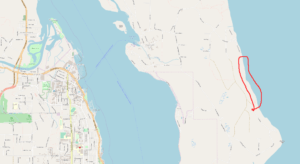
Double click on the above location map to enlarge it, to see Hope Spring/Thompson Trails location, as marked within the red line.

A pod of orca passing the south end of the Kay Dubois Trail during spring of 2018. Cortes Island homes in background photo x G.Ross
The Kay Dubois Trail can be walked from the south end of Wei Wai Kei Road which runs off the east (ocean) end of Smith Road. Or from the southern end of this trail which begins at the north end (near the beach) of Sutil Road, on the ‘south end’ of Quadra Island.
The trail takes about 45 minutes to walk one way and does not climb much but follows the beach level closely, and at times there are little side-trails going from the main trail the few meters or so to the beach. It is a lovely walk and allows good ocean views including Mittlenatch Island, Marina Island and Cortes Island and the magnificent mainland mountains. The trail has recently been upgraded to make it better than ever.
About a third of the way along the trail from its north end, is a large, multi-branched maple tree beside the trail, marked with two round rocks sitting in a crook in the tree, about six feet from the ground, and at this point there is a side-trail behind the tree which goes up to Fox Road Main, a logging road which joins Fox Road with Sutil Road. No vehicles are allowed on this road, but walking it is very popular. The upper end of this side-trail is currently marked with an orange plastic disc nailed to a tree, and begins as an old mossed-over road a few minutes’ walk from the end of Smith Road.

Looking east at Cortes Island with the mainland mountains behind, from the beach beside the Kay Dubois Trail.

The view south from the Kay Dubois Trail alongside the beach, with little Mittlenatch Island in the foreground and Texada Island in the distant background. Mittlenatch Island was used as a target for bombing practice by Lancasters during WW II.

The wonderful beach alongside the Kay Dubois Trail. You never know what you will find washed ashore on the beach in among all the driftwood. A popular route is to walk the trail in one direction then return to your car via the beach.
This page was updated on 3rd August, 2020.

