
Chinese Mountains Trail
Cellphone coverage is good on virtually all of Beeches Mountain Trail, but not good on the Chinese Mountains Trails except at their higher levels where there’s a clear line of sight to Campbell River.The Chinese Mountain and Beeches Mountain trails begin at the same parking lot, and are connected from the south Chinese Mountain Trail up high where the trail is on the summit area of Chinese Mountain, south peak.
The red circle on the map below indicates where the Chinese and Beeches mountains trails are located on Quadra. Click on the map to enlarge.

© Copyright: Open Streets Map copyright: https://www.openstreetmap.org/copyright
Chinese Mountains, south peak, is the most popular trail on Quadra for hikers to climb for a good view of Quadra’s south end, Rebecca Spit, Campbell River, and the islands to the east and south of Quadra. Beeches Mountain is 500′ higher than Chinese Mountains and is connected to the same trail, and takes an additional 30 minutes to climb from Chinese Mountain South Peak, but gives you a considerably better view than from Chinese Mountain South Peak. Both trails begin at the same car-park. Chinese Mountain North Peak, branches off the South Peak Trail about 20 minutes up from the carpark, and now has a short new trail off it near its summit, which offers a superb view of the mainland mountains and of many islands. Well worth a look.
To hike the Chinese Mountains Trail and the Beeches Mountain Trail you drive north from Heriot Bay for about five Kilometers. Go past the Walcan Road on the left then past the fish hatchery on your right, and about 100 meters past the fish hatchery you turn left at the trails signpost and drive up the small dirt road for about .5km to the car-park at the start of the Chinese and Beeches Mountains trails.
Turn off the main road at this signpost to access Beeches and Chinese Mountains trails.

The Chinese Mountains Trail begins at the car-park as does the Beeches Mountain Trail. It is handy to Heriot Bay and although it is a steep climb up to the south summit, it is over quickly, it takes about 40 minutes for the average hiker to hike up onto the south summit plateau.

A new map of bike trails, climbing zones, and hiking trails, above on left, now stands at the start of the Chinese Mtns. and Beeches Mountain Trails. The new map is the white plaque on the post on the left of this above photo, taken from the parking area.
After climbing for 10-15 minutes you will come to this signpost on the trail. Take the left fork to the south Chinese Mountain, for the best view. The north peak view is good too, but not quite as good as the south peak, which is slightly higher than the north peak.

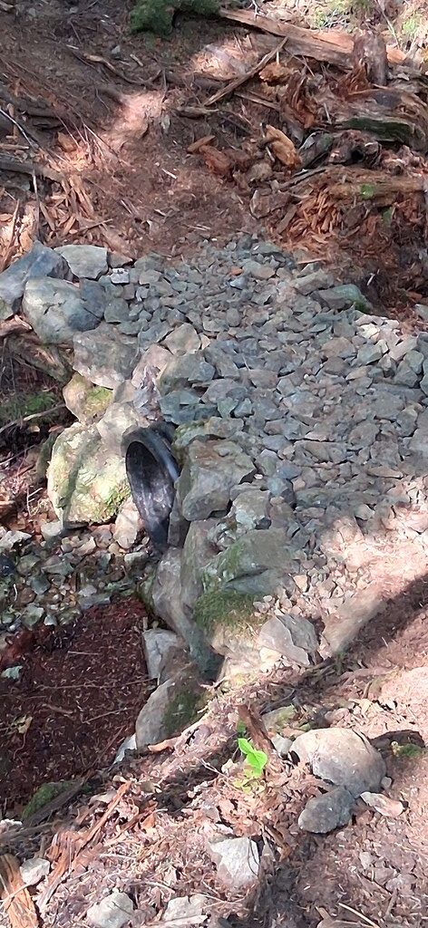
Just five minutes climb past the signpost, after turning off onto the south peak trail, you will come to a stream where the old wooden bridge has been replaced recently by a new culvert over the stream, with the trail atop the culvert. Photo below. Climb on past the culvert and you soon hit a steep section which after about five minutes of climbing, levels off onto a plateau.
Once you have climbed up onto the plateau on the south peak trail, you follow the trail along the plateau right to its end. Enjoy this great view. Its GPS point is: N 50° 8.516′, W 125°15.769′ Its elevation is 1065 ft.
On top of South Chinese Mountain, looking out over Hyacinth Bay, Rebecca Spit, the neighbouring islands, and Quadra’s south end.

The view from Chinese Mountains, south peak, showing Quadra’s southern end.

This dog checks out the splendid view from Chinese Mountains’ south peak.
As you return from the South Chinese Mountain Viewpoint you will pass the signpost shown in the photo below.

This signpost points the way down to the Beeches Mountain Trail, and back to the car-park and your car via a loop. Note the three generations of trails signs on the posts. The top signs are small and were placed there about 25 years ago. The brown signs went up about 20 years ago, and the new post in the foreground has recently been placed there to hold a new set of signs.
From this signpost down to the Beeches Mountain trail takes about 15 minutes, and from there it’s another 25 minutes back down to your car.
A minute or so northwest from this signpost, along the Beeches Mountain Trail option, you will come to an open knob where you will have a view of Morte Lake, Seymour Narrows, and Vancouver Island. This viewpoint is at: N 50 º 8.553′ W 125º 15.884′
THE NORTH CHINESE MOUNTAIN TRAIL
THE NORTH CHINESE MOUNTAIN TRAIL now has a new sub-trail going off it very near its summit, which is only a few hundred meters long and takes you to a great viewpoint, which gives a vastly better view than does the North Peak, just a few hundred meters away. Why did nobody make thius new trail years ago? I guess because nobody knew of the much better view from this new viewpoint.

The start of the new side-trail off the North Peak, Chinese Mountain Trail. 15th May, 2024. What a Superb View From the end of this new trail !

The wonderful new view, from the new trail off the North Chinese Mountain Trail. 15th May, 2024. Photo by Greg Ross
Below: The view south from Chinese Mountains North peak, at: N 50° 8.715′, W 125° 15.645′, elevation 1050 ft.

Beeches Mountain Trail
This trail takes you from the car-park along a short trail to an old logging track, then up that for a short distance to where the old road becomes a hiking trail. At this point there is also a short connector trail down to the Morte Lake Trail. The Beeches trail now curves around the mountainside and climbs steeply up for about 30 minutes to a signpost where a side-trail links you onto the Chinese Mountains Trail via the south peak of Chinese Mountains.

At these signs on the Beeches Mountain Trail you can either go right and climb for 20 minutes to Chinese Mountains’ south peak, or, stay left and continue up to Beeches Mountain.
These signs are at: N50º 08.641′, W 125º 16.038′

Above: Star flowers beside the trail where the trail follows up beside a stream; 16th JUNE, 2022
Above: Star flowers beside the trail where the trail follows up beside a stream; 16th JUNE, 2022
Continue up past the signpost and you will climb through a series of open plateaus, one after another. After 30 minutes you will come to an open plateau giving superb views, where a huge rock sits alone on the open basalt knob which is the first summit of Beeches, also called the ‘false’ summit. The huge boulder was left there by the receding ice sheet about 11,000 years ago, when the west coast of BC was under a one-kilometer-deep sheet of ice. If you look carefully along such exposed areas of basalt you can see groves about six inches to a foot wide, where the ice sheet dragged a rock under much pressure underneath it, so that the rock wore a deep grove into the bedrock. These smooth rounded groves are known as ‘striations’.

Here above is the big rock on the first summit of Beeches Mountain, at: 50º 8.961′, W 125º 16.438′ elevation: 1460 feet.

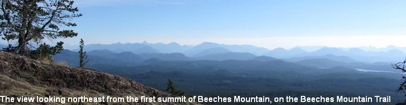
Above is looking northeast from Beeches Mountain’s first summit, at 1467 feet.

Above photo is the most-commonly visited summit of Beeches, which is five minutes’ walk from the true summit. This first summit does give the best view of all viewpoints on Quadra. This photo was taken on 6th July, 2023. The Cortes ferry can be seen coming towards Breton Island and Quadra Island on its first run of the morning. This point on Beeches Mountain is at: N50º 08.963’, W 125º16.435’ and the elevation is 1467’
While on Beeches Mountain on 6th July this grouse(below) made it quite clear this was his turf, and got all puffed up about it and did some serious ‘thumping’.

From the first summit there is a trail sign indicating the direction to go to the true summit of Beeches Mountain. Below is the trail sign at the first summit of Beeches Mountain

Follow the trail for about eight minutes across an easy plateau and through a tiny saddle and you will come to Beeches Mountain’s True summit, at: N 50º 8.996′ W 125º 16. 562’; elevation 1550 feet. The view here is good of the Campbell River area and Vancouver Island’s mountains.

Here is Antje, a German visitor, who regularly comes to Quadra, standing with her dog near the true summit of Beeches Mountain, elevation 1557′, after volunteering in trimming overgrown vegetation along the trail on her way up with another Quadra volunteer .
Above is one of the upper summits of Beeches Mountain, at point: N 50º 09.019’, W 125º 16.561’; it’s about five minutes’ easy walk from the first summit. About 50 meters southwest of this summit, within view from here, is the highest summit of Beeches Mountain, about six feet higher than here, with a cairn at its top, and it’s at: N50°, 08.995’ W125°,16.560’.

A rest is needed for this hiker after climbing the steep final 150 meters of the trail up to Beeches Mountain First Summit. Photo taken July, 2018. What a view !

The summit of Beeches Mountain on 16th June, 2022. This spot offers the best view on Quadra.
This dog below went missing on the Chinese Mountain Trail a few days ago, around 10th November. if you see this dog during your hiking, especially on Chinese Mountains trails or Beeches Mountain Trail or Morte Lake Trail, please call the number below.

If you take a dog into the forest on Quadra, anywhere on the island, in remote areas or on forested trails close beside residential areas, always keep your dog on a leash. There are cougars, wolves, and bears which will prey on dogs and sometimes it happens so quickly and so silently that, one second the dog is there, and in the next second the dog has disappeared.
This page was updated on 19th July, 2025.

During spring on Quadra the skunk cabbage blooms and gives the forest some unusual bright yellow colours.