Here’s the trail with the best view on Quadra Island:
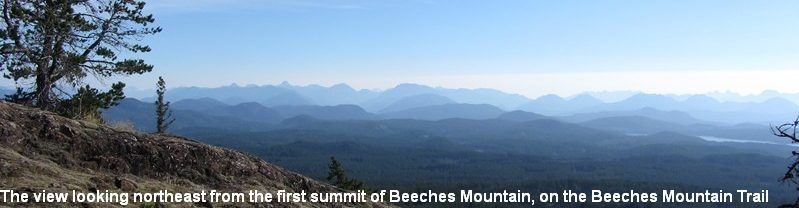
Climb the Beeches Mountain Trail to the summit and on the way back down to the car, pop up to Chinese Mountains South peak and then climb the trail to the north peak. What views! And you should love the beneficial exercise gained by plugging away up these steep trails. The trails are in excellent condition and during fine weather there are usually hikers on them. These two photos below were taken looking northeast and southeast from Beeches Mountain’s 1st summit, on 30th June, 2023.


Come share Quadra’s lovely island hiking trails, native fauna, and scenery with all of Quadra’s visitors and residents. Generally Quadra Island provides easy, safe hiking and outdoors activities, but if you are new to the island or if you are not very experienced in the island’s outdoors you should read this page carefully.
We do our best to clear, mark, and bridge our trails, all with volunteer effort through the Quadra Island Trails Committee, and we have tourists from around the world hiking these trails every summer and telling us year after year how impressed they are with their Quadra Island hiking experiences. However, occasionally hikers become lost and require rescuing. This page of the website is designed to help avoid problems when hiking Quadra’s trails.
An excellent source for Quadra’s trails on an online map website is: GaiaGPS (click on link below)
https://www.gaiagps.com/map/?loc=13.5/-125.1882/50.0643&layer=GaiaTopoRasterMeters
Remember to prepare well for your hike, take plenty of warm clothing, water and food, a cell phone and/or locator beacon are advised, and a small compass as a back-up is also advisable. And if you have any doubts, and for further insurance, ask locals who know these trails about each trail before you hike it. There are cougars, wolves, and black bears on this island so please keep you dog on a leash for its own safety and do not let it run free as it will be there one minute and may vanish into a predator’s tummy the next minute if it’s running free ahead of you. Small children too should not be allowed to run ahead of adults on trails, at all, as this is typically when cougar attacks occur, in front of adults. Cats and small dogs are vulnerable to the many eagles and other predators on the island which can snatch them in a flash if you do not control your small pet very closely.
Camping in non-residential wilderness areas outside of campgrounds is permitted on Quadra provided you keep your campsite clean and leave no litter or other imprints behind you, so that others can enjoy the wilderness after you. Be warned that every summer there is a total ban on all open fires and this must be strictly observed, thank you. The fine for having an open fire during the ban is very severe.
Quadra Island lies across Discovery Passage beside Campbell River, Vancouver Island, and is about 26 miles long and averages about three miles wide. Quadra is heavily forested, and in places is very rugged, with mountains up to 2,000′ high. On the island are numerous well-kept forest trails and forest walks, some near the residential areas and others back in the wilderness where you might see wolf, cougar, or black bear; as well as beaver, mink, otter, and black-tail deer. The views east from Quadra are spectacular as the large photo shows, and many trails have viewpoints east and west. There are some jewels of small and medium lakes on Quadra too; some high up, and other down near roads. The purpose of this website is to give descriptions of Quadra’s trails so that people can access the information online before deciding to hike any particular trail.
Although Quadra is a relatively small island, make no mistake, people do get lost on the trails here; and the terrain is deadly rugged in places with many hidden cliffs, bluffs, and impossible undergrowth.

ABOVE: In November 2018, two middle-age women went for a one-hour afternoon walk up an old trail near Mine Lake and became lost. They then had to survive TWO wet nights out in the open before they were, very fortunately, rescued. The search involved many resources including aircraft, vehicles, and many searchers. The two women found a dry spot under a tree and stayed put until they were found.
Some hikers these days carry a Personal Locator Beacon (PLB) (as shown below) which usually greatly reduces the time taken for searchers to locate the lost or injuries parties. These beacons work anywhere on Earth and send a signal out to satellites which is then beamed down to tracking stations which then alert Search & Rescue and give them your exact location to within ten feet. Rescue often happens within a few hours of activating the beacon. These beacons cost between $350 and $500 depending on the model and the retailer. They can be used in boats as well as on land. Some hikers carry a cell phone and a personal locator beacon.
![]()
For safety, stay on the trails and if you think you are lost, stop immediately, until you are totally calm, and then carefully and slowly backtrack a little way at a time, until you know you are back on the correct trail. Or, stay put as soon as you realize you are lost, and await help via your cell phone calls or locator beacon activation. If you have a cell phone, or locator beacon such as a Spot or ARC, and you are wary of trying to backtrack to the trail, then call for help. Be aware that cellphone coverage is non-existent on certain trails and on certain parts of the island. See each trail’s page on this site for cellphone coverage on that trail. Basically, if there is any slope or rock face between you and Campbell River township, you will not receive cell coverage. You must have a clear line across from your position to Campbell River to receive cell coverage. Heriot Bay has no reception, for example.
Hikers who have become lost on Quadra’s trails have used cell phones to alert rescuers and effect their rescues. The best alternate device to a cellphone is a Personal Locator Beacon (PLB), (SPOT is just one type of PLB,) which will bring rescuers to places where there is no cell phone reception. There is basically no cellphone reception on Quadra Island’s east side, although some cellphone providers may be supplying it in due course. Carry both cellphone AND beacon to be as safe as possible.
Plan your hike carefully, take food and water, extra clothes especially a raincoat no matter what the weather condition is when you start out, and it is advisable to tell someone exactly where you will be hiking and when you expect to return.

Quadra Island Trails Committee Volunteers preparing logs for a new hiking/biking trails bridge near Morte Lake on the Morte Lake Trail, Quadra Island
Quadra Island GENERAL OUTDOORS INFORMATION:
The forest on Quadra comprises mainly fir, but commonly includes western red cedar, sitka spruce, western hemlock, a few arbutus near the ocean, and much alder at lower levels especially on recently cleared areas. Shore pine (also called ‘scrub pine’ and ‘lodge-pole pine’) is especially common around coastal areas and inland around rocky bluffs. Other native shrubs and small trees include nine-bark, Saskatoon, arrow-wood, holly, salmonberry, and huckleberry.
As you gain elevation on Quadra the vegetation changes slightly. Up at the Lily Pond and around Nugedzi lake, which are both 1400 feet above sea level, you find juniper bushes and Labrador tea bushes. These only grow at this altitude or higher.
Many of the streams on Quadra hold good drinking water, but be wary of stagnant water and slower moving streams, especially during warm weather and especially if there has been no heavy rain for a while, or if there are any signs of wildlife such as beaver in the water. Giardia is present in Quadra’s stream water in places, as there are beaver and deer here among other wildlife. Smaller and swift streams, especially ones coming from out of the ground are generally safe to drink at all times.
Beware of tick bites, as Lyme disease is present on Quadra and surrounding islands, although is not common. If you are bitten by a tick and are unsure of Lyme disease symptoms, please carefully research online or visit a doctor, as the correct antibiotic taken as soon as possible can save you huge amounts of suffering and many doctors visits. Lyme disease is rare but is a particularly nasty problem to contract. For protection against tick bites wear long pants and long-sleeved shirt, and avoid bashing through heavy scrub, where ticks can drop onto you. Stay on the trails.
Also beware of wasps nests, which appear every summer, sometimes right on or very near trails, and can be the size of a basket ball, and can be quite dangerous if disturbed. If you disturb a wasps’ nest you will probably be stung once or twice, and then hear the angry mass-buzzing from the nest, and realize what is happening, and then you must run fast away from the spot. Be sure to move away very fast from the buzzing, to minimize the number of stings you get.

This active wasps’ nest, the size of a melon, was built just a few feet directly above the Haskin Farm Trail and on July 20th, 2018, a volunteer trails worker clipping the tree’s branches disturbed it and was attacked but not stung before he quickly fled. The nest was later exterminated. Sometimes it’s not the big things such as bears which hurt people, it is often smaller things such as a nest like this one, or a tiny tick bite, which can escalate into a big problem.
In July, 2019, a young man in Parksville on Vancouver Island died from rabies after a bat flew into him during daylight hours. It hit his hand and must have inflicted a tiny scratch or bite, as, by the time he went to a doctor it was too late for the vaccine to work and he died. Had he got to a hospital immediately after contact with the bat he may have saved his life by taking the vaccine. We have bats on Quadra and if you ever see one acting as if it has been injured or is dead, or if you see one during broad daylight, or seemingly doing unusual things, be very wary of it, and under no circumstances touch it. Only one bat out of every 100 is likely to carry rabies, and bats are the only animals in BC to carry rabies, according to CBC. Raccoons too may carry rabies in BC.

If you are camping or hiking do not leave food or possessions lying around in the open as this can attract wildlife such as bears; and gulls, ravens, and crows will steal things from under your nose and are especially adept at thieving from boats, even going inside the cabin to steal things.
There are a few black bears on Quadra, but they are rarely seen and like to raid ripe fruit trees during late summer and autumn.
In June of 2021 a grizzly bear began killing livestock on Quadra’s south end farms and had to be destroyed by government officers. In 2015 another grizzly bear had to be destroyed at Morte Lake because it was frequenting the popular hiking trail there. Grizzlies are not usually found on Quadra Island, they are usually found only on the mainland which is about five miles from Quadra Island.

Grizzly bears are far more powerful than black bears and must be avoided if possible.
Native wild animals here comprise wolves, cougars, black bears and an occasional grizzly bear. Also, river otters swim in the ocean and in streams here; as do mink. Also raccoons, red squirrels, black-tailed deer (a sub-species of mule deer), deer mice, and bats. Feral cats are seen from time to time but there is a group of volunteers who catch these cats and find good homes for them.
Birds found here include kingfishers, bald eagles, towhees, winter wrens, robins, varying thrushes, song sparrows, night hawks, up to 12 owl species, and turkey vultures and several types of hawks in summer. Common water birds include the great blue heron, the loon, mergansers, scooters, scaups, wood-ducks, mallards, geese, cormorants, shags, gulls, and terns.
Native reptiles and amphibians include salamanders, orange-bellied newts, alligator skinks, garter snakes, tree frogs(which sing loudly) during spring nights), and red-legged frogs.

Orange-bellied newt, very common on Quadra roadsides during spring
If you encounter dangerous wildlife on Quadra, such as an aggressive bear or cougar, or, if you see someone polluting the environment or the ocean, or poaching wildlife, please report it to the Wildlife Service hotline: phone 1-877-952-7277, 24 hours daily, seven days per week. To report illegal dumping of garbage please phone 1-800-331-6007.
To report a forest fire, please phone 1-800-663-5555. For seasonal fire ban information phone 1-800-336-7378.
For any emergency requiring ambulance, police or fire please phone 911.
IF YOU TAKE A DOG ON ANY OF QUADRA’S TRAILS THE DOG SHOULD BE KEPT STRICTLY ON A LEASH, TO AVOID CONFLICT WITH WILDLIFE AND WITH OTHER PEOPLE. IT IS MAINLY FOR THE DOG’S PROTECTION, AS NUMEROUS DOGS HAVE BEEN PREYED UPON BY WOLVES, COUGARS, AND POSSIBLY BEARS over the years here on Quadra. If you take a dog into the forest on Quadra, anywhere on the island, in remote areas or on forested trails close beside residential areas, always keep your dog on a leash. There are cougars, wolves, and bears which will prey on dogs and sometimes it happens so quickly and so silently that, one second the dog is there, and in the next second the dog has disappeared, never to be seen again.
Here is an actual example of why you should always keep your dog leashed while walking in Quadra Island’s forest. Lost on 10th November 2022, as posted on various Facebook Quadra Groups. Extensive searching by numerous people for this dog over the next few days did eventually find the dog alive and well, and it went home with its owners.

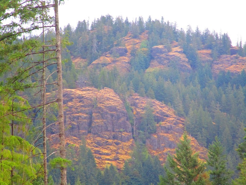
Quadra Island’s glaciated, rugged terrain is fascinating and dramatic, and the vast areas of rock are mostly basalt and granite rock. As you can see in the picture below there are fractures, open faults, cliffs, and steep drops all over Quadra’s wilderness areas. Tread carefully if you are exploring unused parts of this wildernesses.
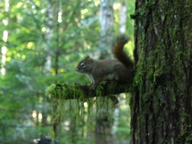
A red squirrel watches its forest neighbourhood, chattering up a storm about newcomers in its Quadra realm
If you feel that you can assist with building this website, with maps, photographs, and/or trail descriptions, or improved versions of current descriptions please forward them to the administration (alpinewriting@gmail.com) and they will be reviewed and maybe used on this site.
 Sometimes it’s the smaller things that are more-interesting. Here is a clump of juniper bushes bearing their berries, at the end of the Lily Pond Trail where there is a good lookout point. Juniper berries are essential in making gin. They are also used in cooking. On Quadra and in Canada generally juniper bushes grow only above 1400′ elevation.
Generally Quadra Island provides easy, safe hiking and outdoors activities. But, never underestimate Mother Nature, and go prepared.
MOUNTAIN BIKING and TRAILS MAPS
For trails maps please go to our Trails Maps Page, which links to the Quadra Island Mountain biking map.
For an up-to-date and easy-to-use streets and roads map of Quadra Island, please open and/or download the free pdf map below, produced late in 2020. It will help you find your way around Quadra’s streets and roads.
Quadra Streets Map. updated in January, 2024.
This website was begun in 2014 by Greg Ross, a volunteer with the Quadra Island Trails Committee. Since 2016, two Quadra residents Mark Lasby and Greg Ross have been running this website which is financed by Mark Lasby.

This is not a sea otter, this is a river otter, and here on Canada’s west coast these river otters live mostly in the ocean around the coast, catching fish and crabs, and are often seen on docks and wharves. This otter recently gave Robin Evans a great photo shoot while it devoured its freshly-caught crab on one of Quadra’s wharves. Thanks for the use of your photo Robin Evans.
this page was updated on 29th., January, 2024.
On tree subject, any of ya seen the large tree right side of main lake heading for entrance channel to little main lake. One tree there is bigger than trees on your web site. One other question while hiking Surge narrows trail recently, noticed over grown in parts any objection if hiking these trails can bring machete to some bush wacking to keep open ?
Thansk for the info re the Surge Narrows trail. No objection to trail-users doing some work to keep the trails open. Thanks for doing so. I have not heard the argument that machetes in particular leave sharp ends, as all other tools also can leave sharp ends. I have not heard that machetes are not allowed. Says who? But, I use only loppers, Swede-saws, folding pocket saws, and secateurs because they are much, much safer than machetes. Slip with a machete, which ain’t hard to do, and you could easily slice yourself badly, and if you’re a long walk from the road and do not have a locator beacon and/or cell phone on you, or have someone who can go for help for you, you could be in very big trouble.
We found the south trail for Stramberg Lake impossible to locate.
Lots of logging activity.
The north end was found but the acces was very muddy and we could not continue.
I realize the trails are maintained and developed by volunteers….just would have liked to visit Stramberg Lake this time in late August.
The south end of the lake has two trails going to it, one from the east and one from the west (from Open Bay Main Road) which meet at a point within a few meters of the lake. These two trails are not easy to locate as they are not maintained by anyone regularly. The best and quickest way to the lake’s south end is via the trail from Open Bay Main Road. This trail does during its course follow a logging road for a short distance and this is where people miss and walk past the true trail turnoff. Hopefully we will have time to put up some better signage during this coming spring/summer 2019 along that route to make it easier to follow. Form Open Bay Main Road to the lake is about 15- 20 mins walk.
Yes, the access to the south end of the lake was drastically altered in 2018/2019 by logging activities, which changed the landscape over that trail entrance to the south end of the lake, which can cause confusion. The route now still goes from the OPEN BAY MAIN logging road, as before, but the first 150M or so is now across open ground to the forest, where it then follows an old logging road, as before, down to a flagged post where the trail branches off to the right and you soon see a Parks sign. From there it is a 10-minute walk along the trail and down to the lake. This same trail also continues on past the lake along old roads and eventually comes out at Village Bay Lakes, at the smaller of the lakes, beside the road there. Since you were there, work has been done on making that south end of the lake easier to find, when hiking in off the Open Bay Main Road.
I had a dream last night that I could teleport to Quadra Island from Victoria through a weird little garden decoration. I started looking up camping/hiking info for the island and came across your site, and I just want to say how nice it is to have all of this information in one place. Thank you so much! I hope I can visit soon.
Reading through your description of the Hopespring/Thompson Trails, and being a regular hiker of those trails, I think you are underestimating your hiking times, especially if one wishes to slow down or stop along the way to appreciate the forest and views. Also, after you reach the intersection of Heriot Ridge and Hopespring Trails, and proceed southwest downhill on Hopespring Trail, you will connect with the Gowlland Trail, not the Thompson Trail. Turn right to proceed north on Gowlland Trail, eventually coming to the junction with Thompson Trail.
Janis, thanks for your comment. I have always seen the Gowland Trail as that branch, of the two branches, at the bottom of that hill, the branch which goes southwest to Gowland Harbour Road, and that the other branch, because it links directly onto the Thompson Trail, as part of the Thompson Trail. The Gowland Harbour Trail is the branch of that system which goes off at the big footbridge on Thompson Trail up to Rosseau Ridge and then down to North Gowland Harbour Road. Often trails and roads are known by two or more names. I will look into it some more though and maybe adjust the relevant webpage info on this site.
Somewhere along the line , Shellalicum Pass had it’s name changed to an Irish sounding Shellaligan. Back in the 70’s ,it was called Shellalicum. A bit more Chinook sounding don’t you think ?
Thanks for that interesting information John. It’s a fact that places’ names change. like common words in the English language evolve from one version to another. Walcan Road, was named Missing Link Road, I believe, but, how many people use that name these days?
AWESOME website, well described and beautiful pictures. There are also very many trails cut through the woods which are less formal but have offered me so much pleasure. Some of these less formal( (well established )) trails are difficult to discover and some are not , nevertheless they go past some beautiful scenery and during the winter season spectacular waterfalls.
Staumberg Lake Trail / Map
Perhaps the “Blue” trail is broken on the website. I know of the rough road / trail leaving the private property :”Trail Sign” takes you left and north to Little Main Lake. This is the section of your map which is missing.
It is down, near Little Main, that one can ford Straumberg Creek to get to the Old Growth Trail.
The location of the “safe to ford” needs to be especially cleared and flagged!
Thanks for the comment Rod, you’re right, the old map was lacking details, which now have been added. Yes, that ford area of Stramberg Creek needs trail-marking and clearing. I am hoping to do that this spring. Greg.
I got lost near the summit of Beeches Mtn today. If it hadn’t been raining, I would have persisted, but with water dripping off the end of my nose, and little chance of getting much of a view from the top since we were totally socked in, I decided to head back down. I spotted a couple of bits of flaggers tape but I quickly realized I was not on the trail and was struggling to make my way over the steep and hazard-strewn hillside. An app I use called maps.me (fantastic BTW if you don’t have cellphone reception or a spot locator) showed that I was below the trail, so I started climbing up the slope in the rain. Thankfully, I spotted a cairn above me, and was quickly able to find the trail and my way down. THANK YOU to the wonderful people who give their time to mark trails like this and all the work you do on all the trails. I have loved my five days of hiking on Quadra and am so grateful for the wonderful work your group does to make the forests of Quadra accessible to hikers. I am an experienced, fit hiker but I am also a solo female so I rely on the goodness of people like you to make it possible to hike on places like Quadra. If it weren’t for that cairn, I might still be out there, soaking, lost or worse. You are wonderful people!
Sorry to take so long to reply Susan. Yes, there are odd bits of flagging tape tied here and there just off our trails, which mark where the old trail went, or, where some individual has decided to make his/her own trail to somewhere or other and we discourage this practice as it does foul up hikers such as you who are unfamiliar with our trails. It is very easy to underestimate the rugged deceptive terrain on Quadra, and what may seem to be a logical shortcut can turn into a prolonged nightmare of being lost in very nasty terrain. Carrying a Personal Locator Beacon (PLB) is the way to go for serious hikers these days. I finally bought a PLB in 2017, an Artex model which requires no subscription and works anywhere on Earth. I also carry a cellphone, as I do plenty of solo hiking and like as many safety tools as possible in my pack.Many parts of Quadra do not get cell reception though, hence the PLB is the back-up in those places. Good hiking, hope you return and hike here some more.
We are very much enjoying your site information, directions and trail maintenance. It would be wonderful to have a ‘donation’ button for those who might wish to contribute to your group. thank you for all your work!
Thank you for your kind words and encouragement. This website was begun in 2014 by Greg Ross, a volunteer with the Quadra Island Trails Committee since 2001. Since 2016, Greg has been assisted in running this website by Mark Lasby, who also finances the site. Both are long-term Quadra Island residents. Neither Greg nor Mark are affiliated with the current Quadra Island Trails Committee. We are 2 private individuals who maintain this website for the enjoyment and safety of Quadra residents and visitors. We are not able to issue donation receipts so we are not able to accept donations.
The Surge Rapids trailhead is poorly marked and is in the wrong location. Some hikers were nearly run over by a local resident backing down to unload his groceries. The trailhead should be on the upper parking lot. There is no outhouse anywhere near so visitors just go in the bush often right near the trail. The parking situation is dismal. There is barely enough for the outer island residents. If hikers and kayakers come, THERE IS NO PLACE TO PARK. The Discovery Lodge folks do not allow parking. The parking lot needs to be expanded. So far no government agency has responded to the need by providing funding.
Stephen
The proper person to raise your concerns about parking with is Jim Abram, the Strathcona Regional District Area C elected representative. Jim can be reached week days between 8 am & 5 pm at jimabram@explornet.ca. Jim’s phone number is in the Quadra phone book.
Nice job on your Surge Narrows to the Beginning of Yeatmen Bay trail Main lake. Doesn’t appear to be hardly any wind falls left on the trail. Clear Sailing Nice trail. Recommend hike.
Hi…, great site for finding trails to hike. Just a thought, the trail to the old fish processing site off of Grant Bay Road, is not hikeable at the moment as a lot of blow downs, one in particular when we went under it and saw the other side is hanging there and could come down on someone trying to go under it. We gave up when we saw all the blowdowns and decided it was a bit dangerous to continue. Just thought I would mention this trails condition so others might want to forgo it. I will be back to try and go to the Benn mine site, that looks interesting. Thank you for your great site describing all these wonderful trails.
Thanks very much Maria. I hiked all of the major Quadra trails last autumn to update them on the quadraislandtrails.ca website, but the trail to the old fish-processing plant was not one of them I hiked, as it gets so little use. I will update it on the website, according to your information. The Benn Mine is well worth a visit, and is not far off (10 – 15 mins walk) the same logging road you took to get to the fish plant trail. Thanks again.
Well your at Ross check out Vic B. Old horse trail from Village Bay Lake to Stramberg lake, appears to be in good shape.
Yes, I hiked the trail from Village Bay Lakes to Stramberg Lake about two years ago and it was navigable at that time, but since then some work has been done on it to open it up and mark it better.